
- Hikes in Arizona
- Grand Canyon / Marble Canyon
- Tonto West (Boucher - Tonto - Bright Angel)
Tonto West (Boucher - Tonto - Bright Angel)

Location
From Flagstaff, take HWY 180 north towards the Grand Canyon. Once you enter the park, you'll head towards the Grand Canyon Village. During the busy season, you will need to take the shuttle from Grand Canyon Village to the Hermit Rest trailhead.
Hike details
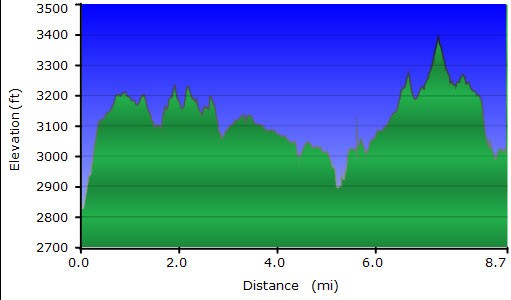
8.7 miles from Boucher creek to Monument creek
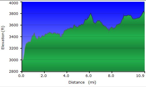
10.9 miles from Monument creek to Indian Gardens
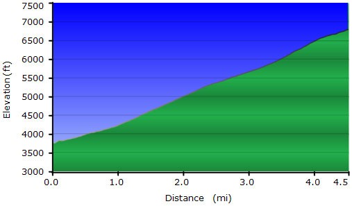
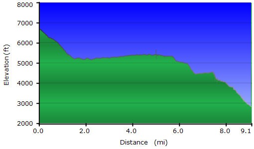
4.5 miles from Indian Gardens to the South Rim
Season
- March
- April
- October
- November
- June
- July
- August
Solitude
Difficulty
Permits
SPECIAL CONSIDERATIONS FOR WINTER AND SUMMER TIMES:
, For Winter Hiking: Remember that the South Rim is damned cold in the winter. Snow and Ice will cover the trail for the first few miles. Crampons recommended.
, For Summer Hiking: Get an early start and don't hike during the heat of the day. Remember that the bottom of the canyon will be MUCH hotter than the top.
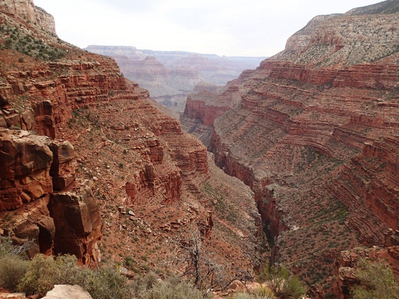
Hike the Tonto Trail (West) in Grand Canyon national park, Arizona. This includes the Boucher trail, the Tonto trail, and the Bright Angel trail.
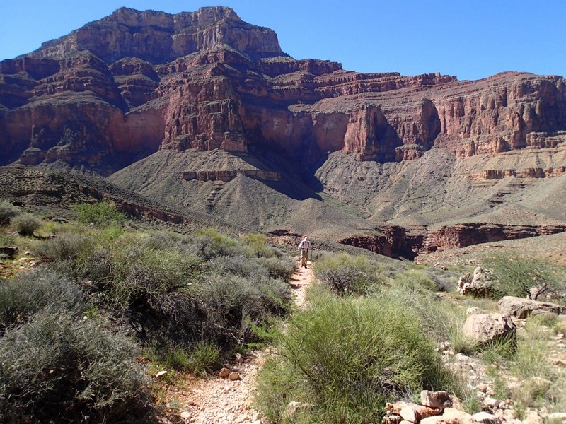
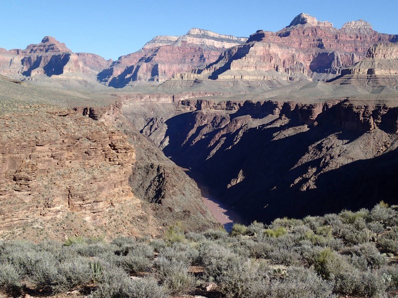
The Tonto trail runs along the inner gorge of the Grand Canyon and remains one of the best backpacking trips to find some solitude in this National Park. The western section of the Tonto can be enjoyed by starting down the Boucher trail and heading east to climb out the Bright Angel trail. Much of this trail is only sporadically maintained. Though easy to follow (nearly all trail junctions are signed), there is some route finding and the trails are significantly more rugged than corridor trails. The easiest way to get to the Boucher trail is to hike from the Hermit trailhead. To get to the trailhead, take the (free) shuttle from the Grand Canyon Village to the Hermit Rest stop. Allow 60 minutes for this, as the shuttle makes seven stops on the way for the gawking tourists. At Hermit Rest is a gift shop, restrooms, and water. Alternatively, the park service gives you the code for the gate if you want to take your car, but you'll have to pick it up again after the hike.
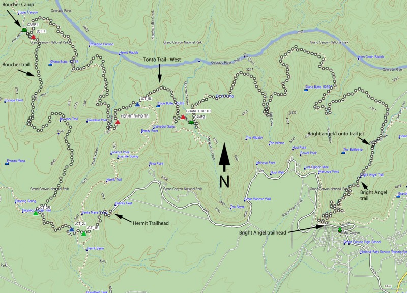
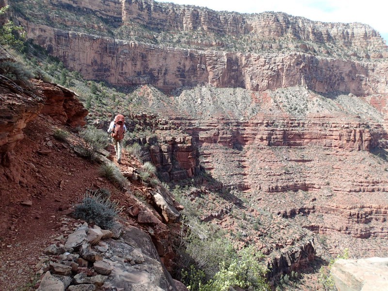
Start on the Hermit trail. Although this trail is not maintained, it is still in reasonably good shape. As the trail descends down the white sandstone region, enjoy the work put in by the Santa Fe railroad when they built this trail in 1910. After 1.2 miles of hiking, you reach the junction of Waldron trail (JCT_1R on the map), which is an alternate route to the rim of the canyon. Stay on the Hermit trail by keeping right here. After 1.5 miles of hiking, you reach the junction of the Dripping Springs trailhead (JCT_2L on the map). To the right is the Hermit Trail to Hermit creek. Stay left here.
You will be walking along the top of the redwall as you skirt the edge of Hermit Canyon. The views of Hermit Canyon are impressive here. After 2.75 miles of hiking, you reach the junction of the Boucher trail (JCT_3R on map). Turn right here to finally start hiking on the Boucher trail. The Boucher trail stays flat as it heads out towards Columbus point. The trail gets quite close to Hermit canyon creating some excitement. You'll lose some elevation as the trail drops into Travertine canyon, then after getting to the saddle at Whites Butte, the trail drops quickly down to Boucher canyon. You'll reach the unsigned junction (watch for cairns) with the Tonto trail (JCT_4 on the map) but after this long day you'll want to camp. We spent our first night camped in Boucher Creek (CAMP1 on the map). This is a primitive area, so there are no toilets or designated campsites. There are clear places that people have camped in the past, so please use one of those. This is a very pleasant area that has year round water. On day two we backtracked to the Tonto (JCT_4) and started hiking East on the Tonto trail. The Tonto trail looks generally flat on the map, but in reality it ducks down and back into side canyons, so there is some elevation change. The first major landmark is Hermit creek. This perennial creek is a designated camping area and is quite scenic. Continuing from the canyon you'll pass the remnants of Hermit camp before reaching the junction with the Hermit trail (JCT_5L on the map). Stay left here to stay on the Tonto trail. There are plenty of great views of the inner gorge as you finally reach Monument creek. The creek was named from the obvious rock pillar in the middle of the perennial creek. There are designated camping sites here (CAMP2 on the map), year round water and a toilet. On day three we continued on the Tonto trail through Salt Creek (seasonal water). After Salt creek, the trail contours around Dana butte until it reaches Horn creek (seasonal water, but not recommended for drinking due to potential contamination by a closed uranium mine upstream). From Horn creek, you'll contour around the Battleship and it is easy to see Indian Gardens with its huge cottonwood trees. The Tonto trail continues East, but we'll be camping in lovely Indian Gardens. Year round treated water, organized camping, and bathrooms are available at this very popular campground. Day four is only 4.5 miles up the Bright Angel trail, but you'll climb over 3000 ft. The trail is well graded so it is a steady climb. This section of trail is one of the most popular in the canyon, so expect to meet lots of people here, especially near the top. Enjoy that feeling of accomplishment as you stop at the South rim to look at the magnificent views of where you hiked.
