
- Hikes in Arizona
- Tucson Area and Southern Arizona
- Sabino Canyon to Bear Canyon loop
Sabino Canyon to Bear Canyon loop


Location
To get to the Trailhead: From the Phoenix area, take I-10 East towards Tucson. Once at the Tucson city limits, take the Ina Road exit East. Continue on this road for 15.2 miles as it changes name from Ina Road to Skyline Drive, and then to Sunrise Drive. Once you reach the intersection for Sabino canyon road, turn left at the light and park in the area just to your right. As of February 2012, the fee to park is $5.
Hike details
- Water
- Wild Flowers
Season
- March
- April
- October
- November
Solitude
Difficulty
Permits
Loop hike via Sabino Canyon and Bear Canyon near Tucson, Arizona.
The loop hike from Sabino canyon over to Bear canyon is a worthy and epic hike from the Sabino Canyon Recreation Area. This area serves as a welcoming environment to the many hikers, bikers, equestrians, and tourists who seek to enjoy the Sonoran Desert. A warning: Sabino Canyon is very popular. On a lovely Saturday morning in February I arrived at the park at 9am to find the parking lot was completely full. Miraculously after a second swing through the parking lot I was able to find what may have been the last spot. So get there early. As of February 2012, the fee is $5 to park.
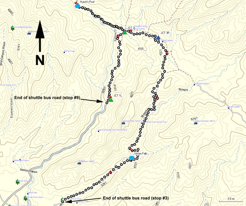
First, head to the booth to get your shuttle ticket. At the time of this hike, the price was $8 (cash only, first shuttle leaves at 9am and every 30 minutes after that). This saves you 4.5 miles of walking through the popular Sabino Canyon area. The drive is scenic, but I don't enjoy hiking through an area that can be driven through. After about 20 minutes, the shuttle will reach the final stop #9 and the start of this hike.
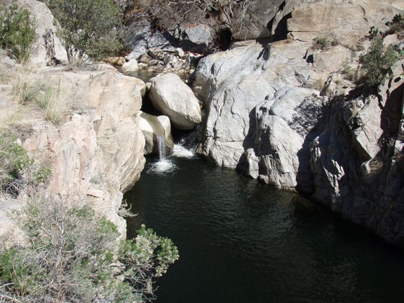
From the shuttle area, follow the well worn trail North into the wilderness. The trail switchbacks up to start as you climb along Sabino Canyon. About 0.5 miles from the trailhead start is the signed junction with the Phoneline Trail (Jct 1L on the map). Stay left here. If you didn't want to pay $8 to take the shuttle, you could have taken the Phoneline trail from the visitor center to this point, however it adds another five miles of one way hiking. Continuing along the trail you'll enjoy excellent views down Sabino canyon to the South. This canyon with rare desert perennial water supports a variety of water loving desert trees including Cottonwoods and Evergreen Oak. After 2.5 miles of hiking you'll reach the signed junction with the West fork and East fork Sabino trails (Jct 2L on the map). Turn left here onto the West Fork trail #24. There is some routefinding here as you cross the creek, but look for the helpful cairns and you should be OK. The trail continues up the West fork, never far from the running creek. After a total of 4.1 miles of hiking, you'll see a cairned spur trail headed towards the creek. This is the short trail to Hutch's Pool. Turn right here and head towards the creek. Hutch's pool is easily seen, with a nice sandy beach along a deep pool fed by a short waterfall. It's a nice place to relax for a moment or even swim in during warmer weather.
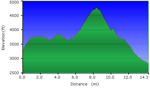
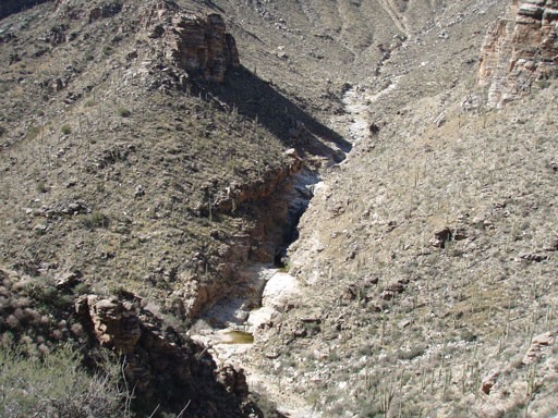
Back track to the Jct 2L on the map and hike along the East Fork trail #24A towards Pine and Sycamore canyons. You'll likely have the trail nearly all to yourself along this section as the well worn trail heads East while climbing up Pine canyon. Looking North, you might be able to see the road up to Mount Lemmon and the popular Windy Point viewpoint. After a good 1000 ft of climbing, you'll reach the top of Bear Canyon, enjoying wonderful views of Thimble peak with the city of Tucson in the distance. The trail heads steadily downhill from here, switch backing down the wall of Bear Canyon to the perennial creek. The trail follows down the canyon on a bench above the creek, eventually reaching excellent views of the Seven Pools. One waterfall gives way to the next, forming seven pools that are appreciated for their beauty and potential for swimming. You'll notice a large number of people here enjoying the falls and depending on the time of year, likely swimming. Continue along the trail which will become much more crowded from people headed the short distance up to the Seven Falls. The trail crosses the creek several times in this section, but nothing too difficult. After a total of 14.3 miles, you'll reach a dirt road with a bench and a water spigot. Don't stop here, this isn't the shuttle station. Continue to hike up the dirt road another 0.2 miles or so until you reach the pavement and the sign for shuttle bus stop #3. If you timed it well (arriving at the top of the hour) there will be a shuttle bus waiting for you. If not, it's another 1.3 miles to the visitor center and your parked car.
