
- Hikes in Arizona
- Prescott Area
- Sierra Prieta
Sierra Prieta

Location
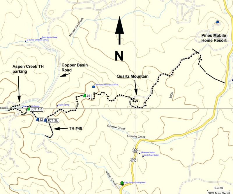
To the Trailhead: From the Phoenix area, take I-17 to the junction of HWY-69. Turn left onto HWY-69 towards Prescott. At the intersection between HWY-89 and HWY-69 towards the town of Prescott, turn left (HWY-69) and head towards the town of Prescott on Gurley Street. When you reach downtown Prescott, you'll arrive at the intersection with Montezuma Street (HWY-89 South). Turn South (left) onto Montezuma Street. After about 1 mile on this road, turn right onto signed Cooper Basin Road. Take Cooper Basin Road for 4.7 miles (the first 3 miles are on pavement, the final 1.7 miles is on good graded dirt road) to the signed trailhead parking for Aspen Creek on your right. The trailhead is across the road from the parking lot and has a small trail sign marking it (TR #48).
Hike details
Season
- April
- May
- September
- October
- January
- February
- December
Solitude
Difficulty
Permits
Hike the Sierra Prieta trail near Prescott, Arizona.
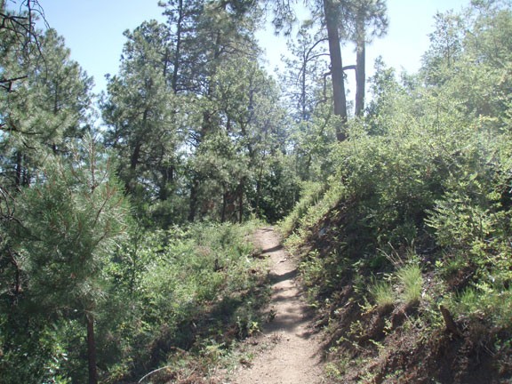
Starting from the Aspen Creek trailhead parking, there are several trailheads that begin here. The one we are interested in is actually across the street from the parking area and is signed as TR #48. This hike will follow TR #48 for the first 0.5 miles before branching off. The easy to follow trail climbs quickly from here through some shaded forest. After about 15 minutes of hiking, the single track trail will intersect with a closed road. Turn right here (Jct 1R on the map) continuing to follow the trail signs for TR #48. After another 0.2 miles of walking along this closed road, you'll reach another trail junction (J2 on the map). Stay left here. Quickly you will reach another intersection (Jct 3L on the map), where signed FR #48 goes off the road to the right. You'll want to go left here, staying on the road. After 30 yards or so you will see a trail sign marking FR9415 on your right. This was an old road now closed to motor vehicle traffic.
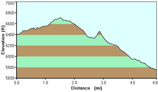
From this point, the tricky route finding eases up and you follow the mostly level dirt road to Mount Wolverton. There are some nice views that peak out from the trees along this section. To your left, you'll see Prescott and Thumb butte. To your right, you'll see the Bradshaw mountains and Goldwater lake. After about 1.6 miles of hiking, you'll reach a gate across the road and a trail sign for FR9415 (J4 on the map). Follow the signed trail to the right where you leave the road and go back to single track hiking.
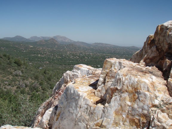
From this point, the forest thins, going from shady pine trees to Gambel and scrub oaks. The shade is mostly gone, but the views are no longer blocked. You'll see your next destination, Quartz Mountain, in the distance as you slowly descend towards it. When you reach Quartz mountain, you'll notice that the trail ends at a series of dirt roads. This area was mined, so the many roads circle the mountain. While facing the mountain, look to your right. You'll see two dirt roads. You want to take the more right dirt road (looks like it descends more quickly) to continue on the trail. Before you do that, be sure to take the time to climb up to the top of Quartz Mountain. Pick one of the roads that looks like it goes upwards and you'll be able to reach the top (with a bit of scrambling at the end). Your reward for this short climb is 360 views of the surrounding area among a sea of quartz rock. This is a very nice spot for lunch and a break.
When ready, backtrack to the road mentioned earlier. You'll be back on an easy to follow dirt road (closed to vehicle traffic). This road is very exposed with no shade. You can follow this road all the way to the Pine Mobile Homes Resort and eventually to HWY-89 if you want. Alternatively, just before entering civilization, there's a signed single track trail intersecting the road that I believe gets you to HWY-89 closer to White Star Campground. These are good options if you are doing this hike as a one way shuttle hike. I wasn't, so I thought this was a good point to turn around and climb back up 900 ft and 4.5 miles to the Aspen Creek trailhead.
