
- Hikes in Arizona
- Superstition and Mazatzal Wilderness
- Cornucopia- Thicket Spring Loop
Cornucopia- Thicket Spring Loop


Location
To get to the trailhead: From the Phoenix area, take HWY87 North, leaving the city limits. You will drive about 35 miles from Fountain Hills to a signed exit between mile marker 222 and 223. The turnoff is signed as Sycamore Canyon. You will turn left across the highway (be careful!). This paved road will soon turn to dirt. After 1.2 miles, turn right onto unsigned dirt road FR201. After another 1.2 miles, you'll stay right at the junction between FR201 and FR25 (staying on FR201). Take FR201 all the way to the signed trailhead (approximately 11 miles from the highway). This road has some spectacular views but is not for those skittish of heights. High clearance vehicles are OK, 4wd is better. Not a place for passenger cars.
Hike details
Season
- March
- April
- May
- June
- September
- October
- November
Solitude
Difficulty
Permits
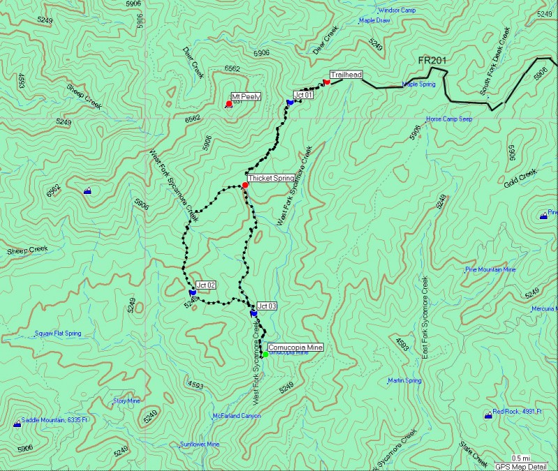
Loop hike with the Cornucopia trail and the Thicket Spring trail in the Mazatzal wilderness, Arizona.
First, you have to get to the trailhead. The dirt road approach to the Mount Peely trailhead has incredible views and you don't have to hike at all. This road is narrow and the penalty for distracted driving is severe, so pay attention. The dirt bike and ATV folks also like this road, so extra vigilance is required.
Once you get to the trailhead, you really get the opportunity to explore this diverse area. The trailhead is at 5500 ft, making this a good summer hike. There are two trails leaving the parking area, you want the one with the large, unmistakable Arizona trail sign. This section of the trail is shaded in pine trees, now more rare thanks to the 2004 Willow Fire. The Cornucopia trail (#86) traverses one face of Mount Peely with wide ranging south facing views of the area.
After 0.5 miles, you will reach the signed junction of the Mazatzal trail on your right (Jct 01 on map). This area of the trail is exposed, with the vegetation being mostly scrub. Stay left and continue another 1.0 mile to the signed junction of the Thicket Spring trail (Thicket Spring on map). There is supposed to be a spring here, but either it is a seasonal spring or I couldn't find it. Turn right here and take the Thicket Spring trail (#95) as it starts a climb up a saddle. This section of trail is still easy to follow but is slightly overgrown. Your climbing will be rewarded with the best views of the hike: Great views of Saddle Mountain, Mount Ord, and the Superstitions in the distance.
The trail begins to head down into the West fork of Sycamore canyon, soon reaching the signed junction (Jct 02 on map) of the West Fork trail (#260). Make a left here onto the West Fork trail. This short trail climbs over a hill and down into the main canyon. Here the seasonal water of the wash changes the vegetation significantly, with oak and sycamore trees being much more prevalent. After only 0.5 miles on the West Fork trail, you'll reach the signed junction (Jct 03 on map) of the Cornucopia trail again. If you turn right and hike 0.5 miles, you'll enjoy some of the nicest scenery of the hike and you'll get to explore some remains of the Cornucopia mine. Turn around at the ruined bus and take the Cornucopia trail back to your car. This section is a steady 1000 ft climb, so you will get that great sense of accomplishment when you finally reach your car.
