- Hikes in Arizona
- Superstition and Mazatzal Wilderness
- Butcher Jones Trail #463
Butcher Jones Trail #463
Location
To get to the trailhead: from the Phoenix area, take HWY-87 North toward Payson. Turn right onto the Bush Highway and go 3 miles to the well signed turn for the Butcher Jones Recreation Area. After turning towards the Butcher Jones Recreation area, you'll drive about 1.8 miles to the well marked trailhead located at the southwest corner of the parking area. There are restrooms here but no drinking water.
Alternate route: Take Ellsworth road in Mesa North to the Bush Highway. Turn right on the Bush Highway towards Saguaro Lake. Turn right at the well signed turn for the Butcher Jones Recreation Area.
Hike details
- Water
- Wild Flowers
Season
- January
- February
- November
- December
- May
- June
- July
- August
- September
Solitude
Difficulty
Permits
Hike the Butcher Jones Trail #463 near Phoenix, Arizona.
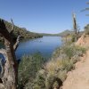
Saguaro Lake is formed by the damming of the Salt River at Stewart Dam and is well loved by boaters and fishermen, especially in the summer months. However, in the winter, the boaters thin out considerably and some nice hiking opportunities open up. The Butcher Jones Trail along the lake edge is an excellent way to experience the area without a boat.
The Tonto National Forest has instituted a parking permit for this area. Unfortunately, you cannot purchase this pass at the trailhead. So if you arrived at the trailhead without a permit, it's about a 20 mile backtrack to get one. So please remember to purchase one in North Mesa before you leave or online (link: http://www.tontopermits.com/). As of April 2013, it is $6 for the tonto pass.
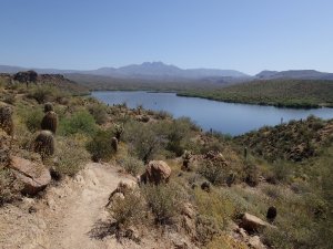
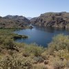
The first half mile has a railing and is partially paved. This section is rather crowded by fisherman looking for lake access. Don't worry, because they seldom hike more than 0.5 miles from the trailhead. The rest of the hike you will have mostly to yourself. The trail contours around the various coves of Saguaro lake, providing some nice views of the lake and surrounding Sonoran desert.
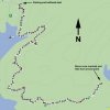
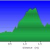
After passing Peregrine point, the hike contours around a small bay and starts a climb up to a small hill. This hill provides some nice views before descending again to just above water level. There are several water access points here and the major trail junctions are well signed (JCT 1L and JCT 2L on the map). Continue to follow the signs pointing towards the Butcher Jones Trail #463. After Camper Cove, the trail heads away from the lake into the desert and over a small saddle to good views of the four peaks and Burro cove. You can probably turn around once you see Burro cove, as lake access would be a nasty bushwack and the trail eventually peters out near the lakeside anyway without any decent lake access or views. Best to make this the turn around point and backtrack to one of the lake access points for a nice lunch.


