
- Hikes in Arizona
- Phoenix Area and Central Arizona
- San Tan Regional Park - San Tan trail loops
San Tan Regional Park - San Tan trail loops

Location
From the Phoenix area, take US-60 East to the Ellsworth Road Exit. Go South on Ellsworth Road, which eventually turns into the Hunt Highway going East. Take the Hunt Highway, turning right onto Thompson Road. From Thompson Road, turn right on Phillips Road and park in the designated parking area. The turn-offs to Thompson Road and Phillips Road are both signed for the San Tan Mountain Regional Park.
Hike details
Season
- January
- February
- March
- April
- September
- October
- November
- December
Solitude
Difficulty
Permits
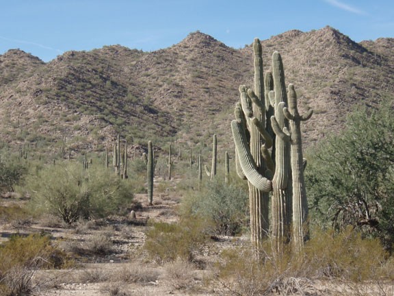
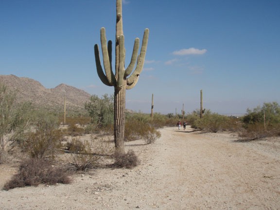
Hiking in the San Tan regional park near Phoenix, Arizona.
San Tan Trail Loops
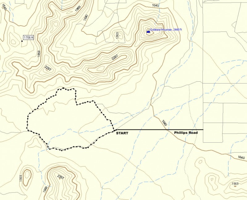
The San Tan trail covers a great deal of ground in the San Tan Regional park. There are two fun loops you can make featuring the San Tan Trail. The longer loop heads south from the trailhead and loops 5.7 miles around an unnamed peak. The shorter loop is 3.2 miles and loops due west of the trailhead. Both are fun and which hike you want to do simply depends on what kind of hike you are in the mood for.
The longer loop of the San Tan Trail starts at the visitors center. Towards the back of the visitors center is an entrance to the park. Don't forget the $6 parking fee.
Follow the signed San Tan trail to the south from the visitor center. It can be sandy walking and there are sections where you are walking in a wash following horse hoof prints. Follow the trail eventually winding through a saddle with views of the west side of the park, including views of the Gila River Indian Community. Here the trail becomes more distinct and easier to follow. This area of the hike is the most picturesque, as you are alone among the Saguaro dotted desert, with towering mountains to your North. Keep your eye out for the area of trail that turns right (North) to make sure you don't walk right out of the park. The trail loops around the unnamed peak and turns back North. Turn right at the signed junction with the Moonlight trail. Then it is a straight shot back to the parking area. Detailed turns at trail junctions for this loop below.
0.6 miles, stay left at the junction with the Stargazer trail
0.9 miles, stay left at the junction with the Hedgehog trail
2.4 miles, stay right at the junction with the Rock Peak Wash trail
2.9 miles, stay right at the junction with the Malpais trail
3.6 miles, stay left at the junction with the Hedgehog trail
3.8 miles, stay right at the junction with the Malpais trail
5.0 miles, turn right onto the Moonlight trail
Stay on this trail 1.2 miles to get back to the parking area
A few days later, we returned to try the shorter Loop. This loop is well marked and starts from the parking area after entering the park and paying your $6 to the nice person at the gate. We did this loop in a counter-clockwise direction to make it easier to navigate. Start hiking on the signed Gold Mile trail. From here, the route finding is minimal as long as you follow the signs pointing for the trail at any trail intersection. This loop is more flat but also exposes you to the solitude of the desert in this park. There are plenty of good views of the Goldmine Mountains to the north. This trail is open to mountain bikers (which yield to hikers) and horseback riders (which you need to yield to) so stay alert. After 1.1 miles, the Goldmine trail ends and you turn left onto the San Tan trail. Take the San Tan trail another 1.5 miles to the intersection with the Moonlight trail. Turn left onto the Moonlight trail and follow it the remaining 1.2 miles to return to your car. Details on each junction of this loop are shown below.
Start hiking on the Goldmine trail
0.6 miles, stay left at junction with Littleleaf trail
1.0 miles, turn left onto San Tan trail
1.4 miles, stay left at junction with Dynamite trail
2.4 miles, turn left onto moonlight trail
Stay on this trail 1.2 miles to get back to the parking area
If you have the time, the memorial to the fallen solders of the Afgan and Iraq wars is well worth the time to visit. It's at the base of the tall flagpole near the visitor center. The details of hiking in this area are sure to change as the park evolves, but this is nice glimpse of what may come.
Link to San Tan Regional Park website: http://www.maricopa.gov/parks/santan/
