
- Hikes in Arizona
- Phoenix Area and Central Arizona
- Sunrise Peak
Sunrise Peak


Location
From the Phoenix area, take state HWY-101 North to the Shea Boulevard exit. Take Shea Blvd East (right) until you reach the intersection of Via Linda. Turn left onto Via Linda. Take Via Linda to 128th street, which is a residential street with no traffic signal. Turn left onto 128th street and drive 0.6 miles to the trailhead on your left. There is parking along the left side of the road.
Hike details
Season
- January
- February
- March
- April
- October
- November
- December
Solitude
Difficulty
Hike to Sunrise peak near Scottsdale, Arizona.
Sometimes even hikes you think will be rather ordinary can hold wonderful surprises. This hike had a fantastic shocker one Friday afternoon for us. Read on for the details...
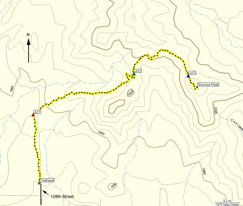
This hike is located in the McDowell Mountain preserve area and features an easy to follow trail with clearly signed trail junctions through the Sonoran Desert.
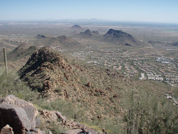
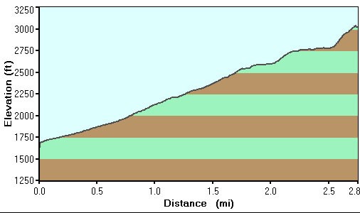
From the parking area take the signed Ringtail trail to the right, towards the McDowell Mountain Preserve. One nice thing about this trail is all the junctions are signed and the entire trail is easy to follow. This section leads through a nice Cholla cactus forest and after about 0.6 miles will reach the junction with the Sunrise trail (shown as Jct 1 on the map). Turn right onto the Sunrise trail which you'll be following all the way to Sunrise peak. It's a steady climb to the peak, but not steep (at least not here). Once in a while, turn around to enjoy the increasingly interesting views of Scottsdale, Camelback mountain, and Piestewa peak.
After climbing and enjoying a few switchbacks, you'll reach a junction with a trail heading down (right) into one of the fancy Scottsdale subdivisions (Jct 2 on the map). Continue on the Sunrise Peak trail (left), which flattens out for a bit as it contours around a canyon. After this contour, you're on a ridgeline. You'll know because there is an easy to recognize hitching post for stock animals. Soon you'll reach the final junction leading to the peak (Jct 3 on the map). Stay right here.
It's a steeper 0.25 mile scramble to the top, but worth the effort. From the peak you have unobstructed views of Scottsdale, Fountain hills, the four peaks, weavers needle, Camelback mountain, and the McDowell Mountain preserve range. This is an excellent place to take a break and enjoy the results of your work.
When ready, return the way you came.
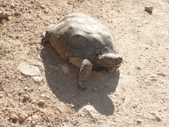
Oh, and remember that surprise I was telling you about? Well on the way back down we nearly tripped over a desert tortoise. Karen first thought it was a rock, until she noticed it had a retractable head attached! We promptly named him Timmy the tortoise. If you see Timmy, be sure to say hi for us.
