
- Hikes in Arizona
- Phoenix Area and Central Arizona
- Pueblo Canyon
Pueblo Canyon

Location
To get to the trailhead: from the Phoenix area, take US-60 East towards Globe. Just after Miami and before globe, take HWY-188 left towards Roosevelt lake. Make a right onto well signed HWY 288. About two miles after crossing the Salt River, turn right onto Cherry Creek Road (signed as FR203), a well graded dirt road. You will continue to follow this road for 23.8 miles. Some waypoints follow (remembering to stay on FR203 the whole time):
After 8.8 miles, a sign for Coon Creek FR203 takes you across the creek and onto private property. Please respect this property so we can continue to have access to this area.
After 13.3 miles, a sign marks the road for Bull Canyon.
After 20.5 miles, you pass the Ellison Ranch. After this point, the road becomes 4WD mandatory. You need to cross Cherry creek here and depending on the season this could require a pretty good high clearance on your vehicle.
After 21 miles, you will see a sign that explains the "Sierra Ancha Cliff Dwellings" in this area.
After 22 miles you will pass the hiking start for Devils Chasm.
After 23.8 miles you will pass over a partially buried steel drainage pipe. Find a place to park, as the trailhead start is within 100 ft of this pipe. This is also the start of the hike to the Cooper Fork ruins.
Please do not underestimate this road. Getting stuck out here would be a lonely experience.
Hike details
Season
- January
- February
- March
- April
- October
- November
- December
Solitude
Difficulty
Permits
Hike to the ruins in Pueblo Canyon, Arizona
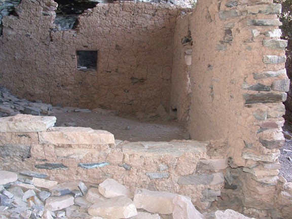
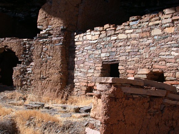
The impressive ruins that are the destination for this hike were built and occupied by the Salado Native Americans between 1280 and 1350 AD. You will appreciate these ruins even more as a result of the difficult approach needed to reach them.
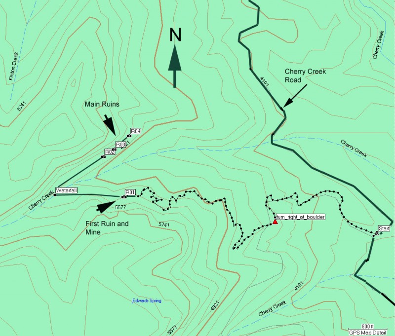
The hike starts at the old mining road leading across the Cherry Creek road. Look on the left side of the road, you'll see a clear dirt track that crosses Cherry Creek road and then heads down to the creek. Head uphill on this tough road. You could drive it, but it's not worth it, because it's not too far from the wilderness boundary... meaning no motor vehicles. Step over the barrier and continue up this easily followed road.
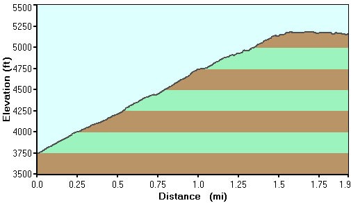
After about a mile, you will have gained about 1000 ft of elevation, which is much easier to do on this road then on a rocky trail. The trail continues up, but now starts to narrow and hints at the future bushwhacking to come. Keep an eye out for an unsigned split in the trail, marked on the right by a large (10 ft high or so) boulder with a curious spiral petroglyph (probably not legitimate) on it. There is also a pink ribbon tied to a tree to note this junction (marked on map). Turn right here.
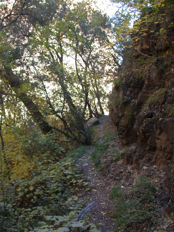
After some additional climbing you'll start into the bushwhacking. It's recommended to wear a long sleeve shirt and long pants for this trail to prevent the multitude of scratches you'll receive from the attacking trees. I'll be honest, it's not enjoyable. Of course, the harder you have to work for something, the more you appreciate it... right?? At least one benefit is the impressive greenery in the area. If you're lucky enough to be taking this hike in the fall, you'll be greeted by a fantastic kaleidoscope of colors here.
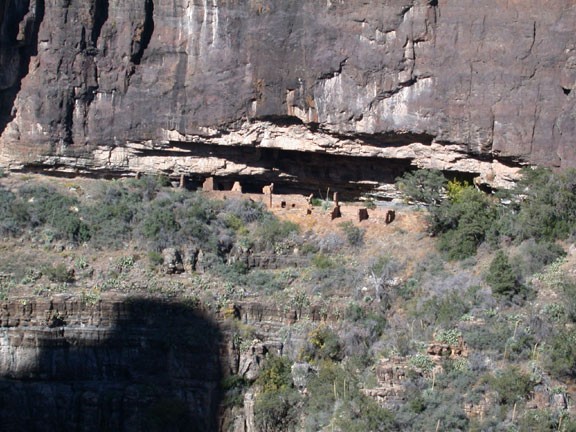
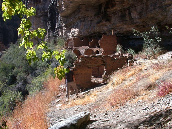
Luckily, the trail is not too difficult to follow, but it is overgrown, so look carefully and use those route finding skills. The trail contours into Pueblo canyon, soon revealing views of the ruins across the canyon. They look pretty close, but to get to them, you have to continue along the trail that reaches the end of the canyon and then backtrack on the other side with the ruins. Be sure to check out the impressive views of the surrounding area on the rare occasion the vegetation clears.
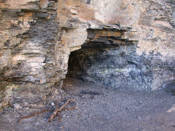
The first ruin you'll reach is just a taste of what is to come. Interestingly, it's placed right next to an old uranium mine. After checking out the first ruin (marked R01 on the map) continue along the trail to a waterfall. On another trail in Arizona, the waterfall would mark the climax of the hike. However, on this hike it's just one of the many enjoyable features. Walk along the trail behind the waterfall and enter the sunlight for the final stretch to the ruins.
There are three groups of ruins along this canyon wall (marked as R02, R03, and R04 on the map) and it's worth the time to check them all. They are remarkably well preserved and the sheer volume of rooms signifies this as a major settlement. Take your time to enjoy this area and be sure to take lots of pictures (but take nothing else!). Please be extremely respectful of the fragile nature of these ruins so they can be enjoyed by the next hikers.
Return by the same route.
