
- Hikes in Arizona
- Mogollon Rim
- Canyon Point Rim View Trail
Canyon Point Rim View Trail
Updated


Location
How to Get There
This hike is located near Payson, AZ.
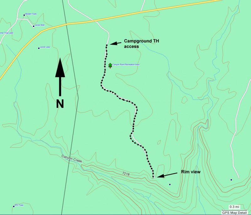
To get to the trailhead: from the Phoenix area, take HWY-87 North toward Payson. Once in Payson, take HWY-260 East towards Heber. After 36 miles of driving, make a right at the signed turnoff to Canyon Point Campground. Take the B camping loop and keep an eye on your right for the signed trailhead. My guess is there are other ways to this trailhead as well.
To get to the trailhead: from the Phoenix area, take HWY-87 North toward Payson. Once in Payson, take HWY-260 East towards Heber. After 36 miles of driving, make a right at the signed turnoff to Canyon Point Campground. Take the B camping loop and keep an eye on your right for the signed trailhead. My guess is there are other ways to this trailhead as well.
addressone
Canyon Point Campground
city
Payson
state
AZ
country
USA
Region
Mogollon Rim
Hike details
Distance
4.00 [Miles] Total
Hike Distance- Details
To the view and back is 4.0 miles.
Time
2.00 [Hours]
Time-details
It took us about two hours.
Elevation Change
200 Total gain/loss [Feet]
Elevation Loss
100 Total Elevation Loss[Feet]
Elevation Details
about 100 ft loss to the rim view.
Hike Trail Type
Out and Back
Season
Best Season
- March
- April
- May
- June
- July
- August
- September
- October
Worst Season
- January
- December
Season Details
Spring, Summer, Fall
Date Hike completed
September 13, 2009
Solitude
Solitude
Low
Solitude Details
You'll probably share this hike with between 5-20 hikers.
Difficulty
difficulty detail
Be Aware of: The trailhead is a little tricky to find as it is buried inside a large campground.
30 yr old Recommendation: This is a good hike for the kids. Bring them along on this easy hike.
30 yr old Recommendation: This is a good hike for the kids. Bring them along on this easy hike.
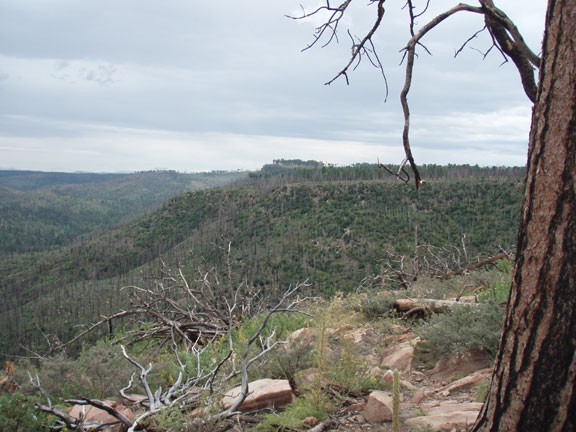
Hike the Canyon point rim view trail on the Mogollon rim of Arizona.
This well marked walk to a view off of the Mogollon rim is a very nice hike for kids or beginning hikers. The hike starts within the spacious Canyon Point campground. The trail goes through the pine forest, through a fence, and into a more dense pine forest. The trail is actually a old road, now closed to vehicles. After a short amount of flat hiking, you will reach the edge of the Mogollon rim, which some rewarding views.
The views here provide a good view of some of the effects of the Rodeo-Chediski fire in 2002. You'll notice the new growth signaling that the forest is starting it's recovery.
When ready, return the way you came.
