
- Hikes in Arizona
- Prescott Area
- Gaddes Canyon Trail #9037 (Upper)
Gaddes Canyon Trail #9037 (Upper)

Location
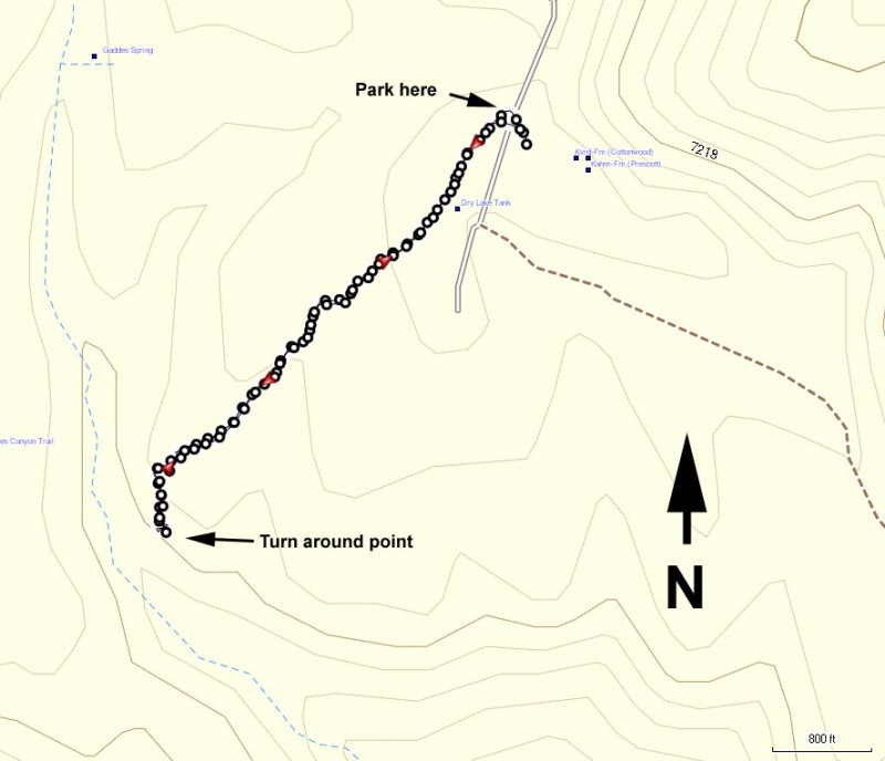
To get to the trailhead: from the Phoenix area, take I-17 North toward Flagstaff. At Cordes Junction, take HWY-69 towards Prescott. To short cut the distance, take Fain Road North to bypass Prescott and head directly to HWY-89A. Take HWY-89A East towards Jerome. At the summit of Mingus mountain, turn right on the signed junction for the Methodist Camp (FR104). Take the well graded dirt road FR104 for 2 mile, following the signs that lead to the Methodist camp. After passing the camp, continue towards the signed Mingus campground. Once you reach the campground, turn right and continue through the campground, following the signs for trail #108 and trail #9037 (about 0.7 miles from the entrance to the campground). There will be a spur road to your right that will be very near the big radio towers. Keep an eye out for the trail marker for TR9037 on your right and park here.
Hike details
Season
- May
- June
- July
- August
- January
- February
- December
Solitude
Difficulty
Permits
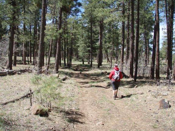
Hike the Gaddes Canyon trail near Prescott, Arizona.
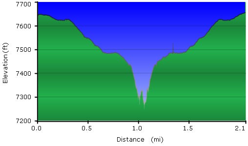
This hike was supposed to be part of a loop hike that included The nearby Coleman Trail #108. We started at the marked trailhead and walked along a dirt road that started as a clear trail through the Pine forest of Mingus Mountain. On your left you pass a cattle tank of water clearly visible near the trail. Gradually, the trail became more faint and we began to follow clearly placed rock cairns along an increasingly rocky route. After about 0.8 miles of hiking, you'll see Gaddes Canyon through the pines as the trail begins it's descent into it. Unfortunately for us, as the trail became more overgrown the rock cairns disappeared and there was no clear way to the bottom of the canyon. Rather than begin a route finding and bushwhacking expedition, we decided to turn back here and head back to the trailhead. Supposedly, this trail goes to the bottom of Gaddes Canyon and reaches FR413, but we sure couldn't find it. Until some serious trail maintenance happens on this one, I'd recommend it as an out and back to the rim of Gaddes Canyon.
