
- Hikes in Arizona
- Prescott Area
- Cedar Spring
Cedar Spring


Location
WEST TRAILHEAD: From the Phoenix area, take I-17 north to the HWY-69 exit. Take HWY-69 towards Prescott. After the HWY-89/HWY-69 intersection, take HWY-89 West, which is Sheldon Street. From Sheldon Street, turn right onto Montezuma Street. When this street turns west, it turns into Whipple Street. Continue on Whipple Street until it turns into Iron Springs road (at the intesection with Willow Creek Road). From here, Iron Springs Road heads North West. From this intersection, drive about 8.4 miles and turn right onto signed dirt road Contreras Road (FR336). This is a well graded dirt road. Take this road for 3.8 miles to a T intersection with signed Tonto Road. Turn right (also FR102) and take this road for 2 miles to a signed cattle guard. Just after the cattle guard, turn right onto FR41. FR41 requires a high clearance vehicle. Take FR41 for 0.3 miles. At the fork, bear right. After 0.3 miles, go under a bridge and turn left onto FR671. Drive 1.6 miles on FR671 to a gate. Unsigned trail #41 is on your right about 100 yards away, through yet another gate.
EAST TRAILHEAD: From the Phoenix area, take I-17 north to the HWY-69 exit. Take HWY-69 towards Prescott. After the HWY-89/HWY-69 intersection, take HWY-89 West, which is Sheldon Street. From Sheldon Street, turn right onto Montezuma Street. When this street turns west, it turns into Whipple Street. Continue on Whipple Street until it turns into Iron Springs road (at the intesection with Willow Creek Road). From here, Iron Springs Road heads North West. From this intersection, drive about 6.2 miles at the signed trailhead for Little Granite Mountain Trail #37.
Hike details
Season
- April
- October
Solitude
Difficulty
30 yr old Recommendation: We really enjoyed this hike, even though the weather didn't cooperate. As you climb, the views and scenery gets more and more impressive. This is a moderate difficulty day hike.
Permits
Hike the Cesar spring trail near Prescott, Arizona.
We had a rare opportunity to take a hike that normally requires a shuttle, as a result of a generous offer from one of our hiking buddies. We decided to take Cedar Springs Trail #41 across to Blair Pass, then finish on Little Granite Mountain trail #37. Everything went well except for the weather.
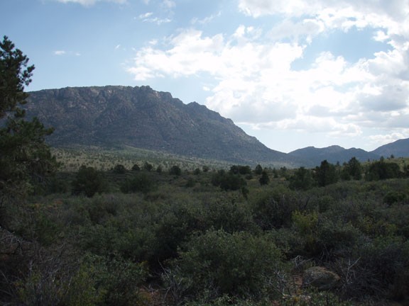
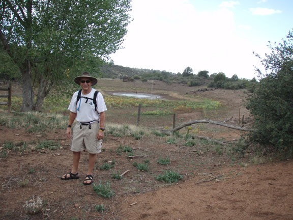
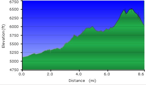
From the West trailhead, go through the gate and start walking along the easy to follow dirt road (close all gates behind you on this hike). This dirt road is closed to vehicles. At this lower elevation, you'll be walking through mostly scrub chaparral and Junipers. Granite mountain will be shadowing you on your left for most of the hike. After about 2 miles, the road will end at Red Hill Tank. This area is easy to recognize as it is clear this area is still used for cattle grazing, being surrounded by fences and a water tank within. Use your route finding skills carefully here to find the trail on the other side of this fenced area. You'll know you're on the trail when you see a sign for Cedar spring. It's another mile of hiking to Cedar spring and the trail can be overgrown and difficult to follow. Tread carefully and stay on the trail by looking for cairns on the ground and blazes on the trees. After about 0.3 miles from Red Hill tank, you'll reach a signed trail junction (JCT 1L on the map). Stay left here. Another 0.4 miles of hiking will put you at the signed Cedar spring. There are a few aspen here that indicate some ground water available. It started raining on us at this time, so we didn't spend much time looking for the spring. Continue your route finding until reaching the junction with TR39 (JCT 2L on the map). Thankfully, the trail is much more defined and easier to follow from this point.
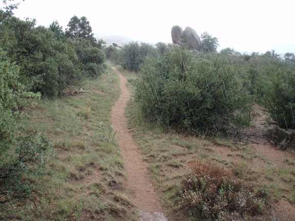
Stay left (headed East) at this latest trail junction, signed as heading towards Blair Pass. This section of the trail starts the climbing that will remain for much of the duration of the hike. You'll also be treated to unique monolithic rock formations, as well as good views of Granite Mountain. Once in a while, turn around to enjoy the views of Skull Valley. After about 1.1 miles of hiking, you'll reach Blair pass.
Now take the Little Granite Mountain trail (TR37) heading south from here (right, signed as heading towards Iron Springs road). Don't believe the distance on the sign, it's only about 3.5 miles to Iron Springs road and the East Trailhead from this point. This area was really lovely, with more views of Skull valley and more cool rock formations. Unfortunately for us, the rain was growing in strength, so I couldn't take pictures of this area. After 1.2 miles of hiking, you'll reach the signed trail junction with TR38. Stay left here and continue on TR37. On your left is Little Granite mountain and you'll continue to climb up the Western face of it. After 1.3 miles of hiking, you'll reach the junction with TR40. Stay right and after a bit more climbing, start the descent towards Iron Springs road and the Eastern Trail junction.
The day we took this hike, the weather forecast did not mention rain, just partly cloudy. Despite this, the rain was on and off for about half the hike. Through our experience, we always carry rain jackets while hiking in Arizona. Even if it doesn't rain, they're excellent at adding warmth if the temperature is colder than anticipated. On this hike, they kept us dryer and warmer than we would have been. It was a powerful reminder of a lesson we learned long ago. Be prepared for sudden changes in weather while hiking in Arizona.
