
- Hikes in Arizona
- Prescott Area
- Goldwater Lake Trail #396
Goldwater Lake Trail #396

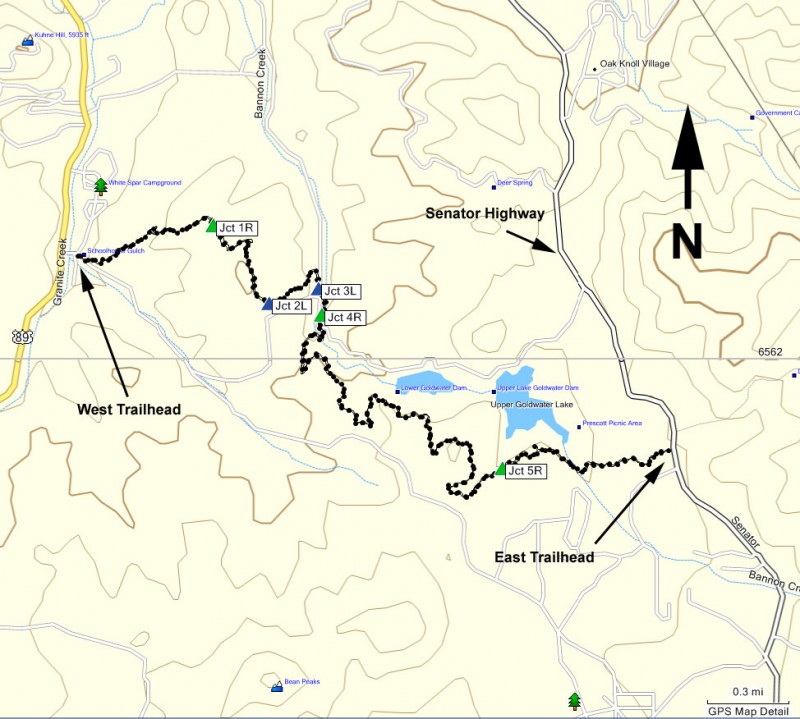
Location
To the West Trailhead: From the Phoenix area, take I-17 to the junction of HWY-69. Turn left onto HWY-69 towards Prescott. At the intersection between HWY-89 and HWY-69 towards the town of Prescott, turn left (HWY-69) and head towards downtown Prescott on Gurley Street. When you get to the downtown Prescott area, turn left onto Montezuma street, which turns into HWY-89 south. Take this road for about 2.7 miles (it will soon turn into White Spar Road). After 2.7 miles, turn left at the signed turn for the White Spar campground. Park at the clearing immediately on your right. The trailhead starts at the gated dirt road. Look for the trail marker sign T0396.
To the East Trailhead: From the Phoenix area, take I-17 to the junction of HWY-69. Turn left onto HWY-69 towards Prescott. At the intersection between HWY-89 and HWY-69 towards the town of Prescott, turn left (HWY-69) and head towards the town of Prescott on Gurley Street. Turn left on Mount Vernon Avenue which eventually becomes the Senator Highway. Take this road 4.1 miles to the large parking area on the left. Pick up the signed trailhead for the Goldwater Lakes Trail #396 by walking across the Senator highway from the parking area.
Hike details
Season
- April
- May
- September
- October
- January
- February
- December
Solitude
Difficulty
Permits
Hike along the Goldwater lake trail near Prescott, Arizona.
The Goldwater Lake trail #396 is a pleasant and enjoyable forest walk that tantalizes you with glimpses of Goldwater Lake and some nice views of the surrounding Prescott National Forest.
There are several ways to take this hike. If you decide to hike from the East trailhead, you will be walking generally downhill. We parked at the West trailhead and did an out and back to the East trailhead so this write up will reflect this. You could also easily do a car or mountain bike shuttle if you were only interested in a one way hike.
From the west trailhead go around the gate blocking cars from the dirt road leading from the parking area. Look for the small T0396 sign to make sure you pick the correct gate. Very quickly trail #396 turns left off of this old dirt road (look for the trail sign) and becomes a single track trail the rest of the way.
There are many trail junctions throughout this hike. Luckily, they are all signed so if you are confused about which direction to go, look for the signs marking trail #396. If there is no trail marker, look along the ground as it may have been blown down or knocked over.
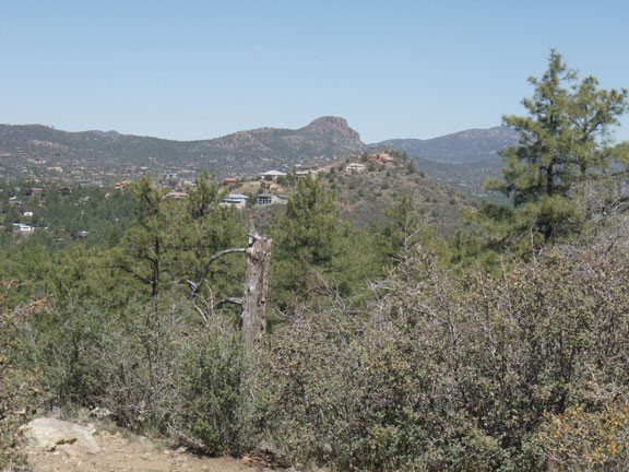
Trail #396 skirts the edge of the campground, passing the signed trail junction to trail #372 (stay right here) and about 0.7 miles from the start passes the signed trail junction to trail #374 (shown on the map as Jct 1R). The trail climbs steadily, with the pine forest providing some periodic shade. When the forest suddenly clears away, you'll get a good view of Thumb butte, Granite Mountain, and the town of Prescott if you look back over your right shoulder.
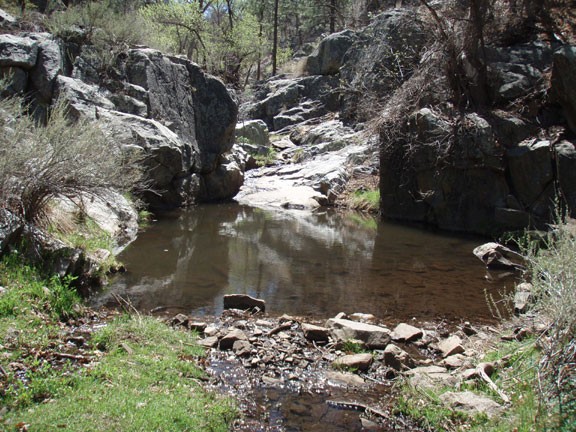
Continue along the easy to follow trail. As the forest shade returns, the trail skirts Banning creek for a while until you reach a very pleasant section of Banning creek that forms a small pool as it flows over some rocks.
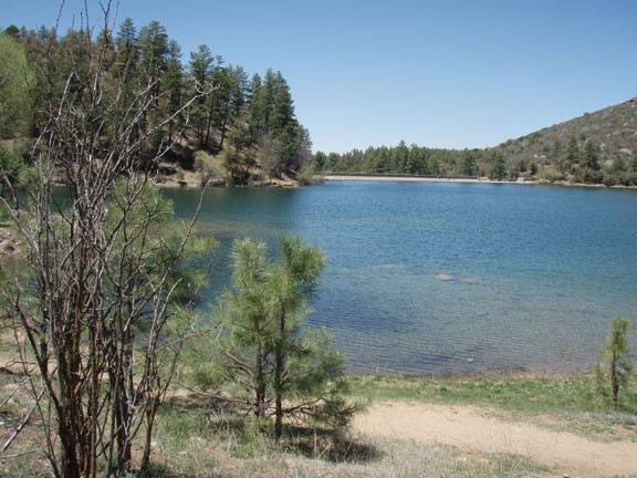
Continuing along the trail, you'll soon see lower Goldwater Lake peaking through the trees. These fleeting glimpses of the lake will stay with you for a while as the trail contours along the hillsides. Unfortunately, this trail never does get to the lakeside. So if you want a good view of the lake, wait until you reach upper Goldwater Lake and then take one of the short, signed spur trails to the lake.
After another crossing of Banning creek, you'll leave Goldwater Lake behind. The forest thins out again until it reaches the Senator highway and the East trailhead.
Return the way you came.
