
- Hikes in Arizona
- Phoenix Area and Central Arizona
- Coon Creek Ruins
Coon Creek Ruins


Location
To get to the trailhead: from the Phoenix area, take US-60 East towards Globe. Just after Miami and before globe, take HWY-88 (or 188 depending on the sign) left towards Roosevelt. Make a right onto well signed HWY 288. About 2 miles after crossing the Salt River, turn right onto Cherry Creek Road (signed as FR203), a well graded dirt road. You will continue to follow this road for 7.75 miles. On your left is signed FR38. Park nearby and start hiking here.
Hike details
Season
- January
- February
- March
- April
- October
- November
- December
Solitude
Difficulty
Permits
Hiking to Coon Creek ruins in Arizona.
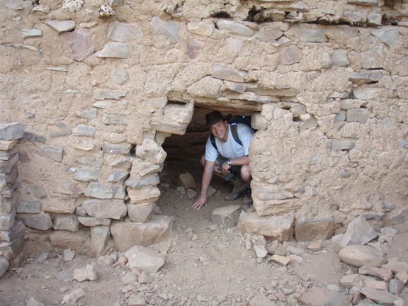
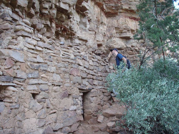
The ruins that are the destination for this hike were built and occupied by the Salado Native Americans between 1280 and 1350 AD. While not as picturesque as the Devil's Chasm ruins or as impressive as the Pueblo Canyon Ruins, getting to these ruins is much easier hiking. Luckily, these ruins are well preserved as well, so you are rewarded for your efforts.
The hike starts at the 4WD road FR38. You could drive this if you had an ATV, but it makes for a nice hike as well. After 1.7 miles of hiking, take the right fork to hike on signed FR1076. In another 0.2 miles, stay left at this road fork.
From this junction, the road will gain elevation and start heading towards Coon Creek, but kind of parallel to it. After another 1.4 miles, you'll reach the top of a saddle. Keep an eye out for another ATV size track on your right as you hike down this saddle. Turn right onto this track, which heads more directly towards Coon Creek.
Here you'll need your route finding abilities as a trail parallels Coon Creek (which depending on the season may or may not have water in it here). The trail will head downstream (right). Keep your eye on the right side of this hill to see the trail that heads up to the ruins, about 50 ft above the creek. You can't see the ruins from the creek, so you'll need to find this trail. This section is overgrown so you'll need to do some mild bushwhacking.
The ruins are in reasonably good shape. There are about four rooms in various conditions. There's also a roof that's still partially intact. Plan on spending some time here to enjoy the history and daydream about living in this environment 800 years ago. Please leave these ruins the way you found them and be very careful during your exploration. They are quite fragile. Make sure they stick around in their current condition for the next generation to enjoy.
When ready, return by the same route.
