
- Hikes in Arizona
- Prescott Area
- Groom Creek Loop
Groom Creek Loop
Location
To the Trailhead: From the Phoenix area, take I-17 to the junction of HWY-69. Turn left onto HWY-69 towards Prescott. At the intersection between HWY-89 and HWY-69 towards the town of Prescott, turn left (HWY-69) and head towards the town of Prescott on Gurley Street. Not long after this turn-off, you will turn left (South) on Mount Vernon Street. From this point, it is 6.7 miles on a paved road (Known as the Senator Highway and FR-52)to the signed trailhead parking. The signed turn-off reads "Trailhead #307". There is a pit toilet at the trailhead, but no water.
Hike details
Season
- March
- April
- May
- September
- October
- January
- February
- December
Solitude
Difficulty
Permits
Hike the Groom Creek loop in Prescott, Arizona.
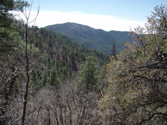
While driving on Mount Vernon street through the charming old houses, it would be difficult to imagine that in just a few miles you would emerge into the Prescott National Forest. The Groom Creek Loop trail is an excellent way to get a feeling for this area. The loop hike described here is in a clock-wise direction, but either way would be enjoyable.
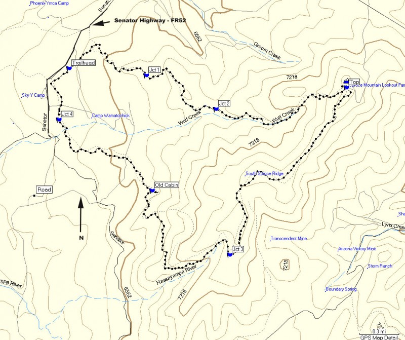
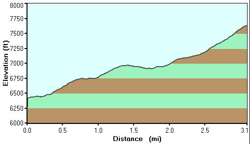
From the trailhead, head North-east (left) through the pine and juniper trees. This section of the trail is nicely shaded and the trail throughout this hike is well worn and easy to follow. On your left are some nice granite boulders where some rock climbers can practicing their bouldering skills. There are two trail junctions (marked as JCT 1 and JCT2 on the map) to navigate as the trail climbs at a gentle to moderate rate towards the top of Spruce Mountain. Even though these trail junctions are signed, the signs can be a bit confusing. Make sure you follow the trail arrows pointing towards trail #307 throughout this hike. At the second junction, you want to go straight towards Spruce Mountain.
After about 2.7 miles of hiking and 1200 ft of elevation gain, you will reach the top of Spruce Mountain at FR52A. There are a few picnic tables here and this is a nice place for lunch and a break. If you walk to your left for a few hundred yards, you can experience some great views of Prescott, Granite Mountain, and Mingus Mountain at the base of a fire lookout tower. If the lookout tower is occupied, they may let you climb to the top for views to the east as well.
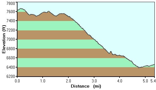
From the picnic tables, continue along trail #307 past the radio towers and begin the long gradual descent along Spruce Ridge. This section of the trail is less shady and there are views to the south that poke out from the trees on occasion. After hiking a total of 4.7 miles, there is another trail junction to navigate (marked as JCT 3 on themap) as well as an old cabin (also labeled as such on the map) after hiking a total of 5.8 miles on your way back down.
At the 7 mile mark, the trail comes into view of FR52 again and follows this road (with some distance away) back to the trailhead.
