
- Hikes in Arizona
- Grand Canyon / Marble Canyon
- Hermit trail to Hermit Campground
Hermit trail to Hermit Campground


Location
From Flagstaff, take HWY 180 north towards the Grand Canyon. Once you enter the park, you'll head towards the Grand Canyon Village. During the busy season, you will need to take the shuttle from Grand Canyon Village to the Hermit Rest trailhead. If you have a backcountry permit, you can drive this road yourself... 8 miles along the west rim road to Hermit Rest trailhead.
Hike details
Season
- March
- April
- October
- November
- June
- July
- August
Solitude
Difficulty
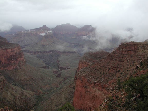
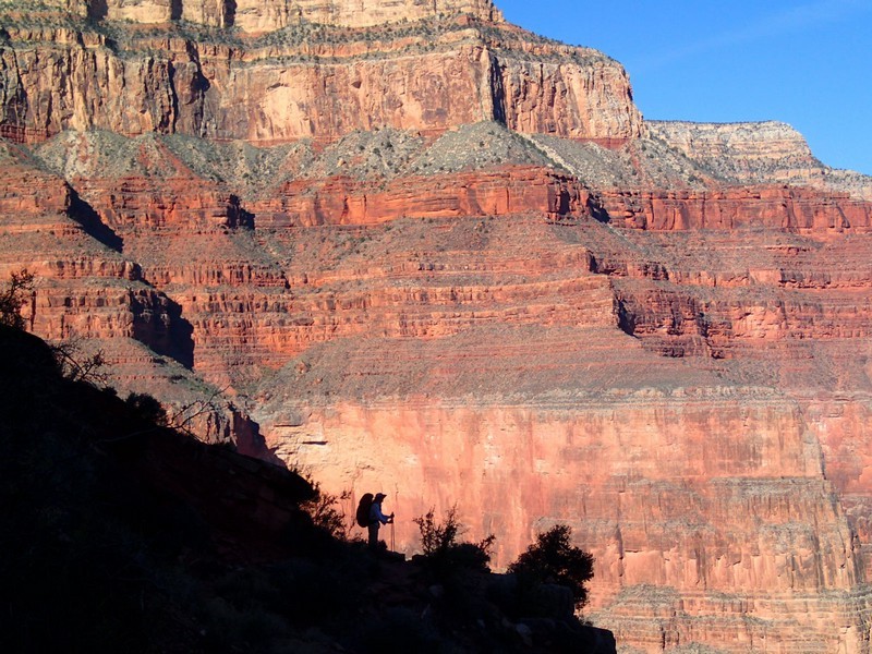
The trail itself is beautiful and in reasonably good shape, considering it is not maintained by the park. The views rival anything on the Bright Angel or South Kaibab trails. Hermit Creek itself is a gem of a canyon and worth the day of exploring. I really enjoyed this hike.
Permits
SPECIAL CONSIDERATIONS FOR WINTER AND SUMMER TIMES:
For Winter Hiking: Remember that the South Rim is damned cold in the winter. Snow and Ice will cover the trail for the first few miles. Crampons recommended.
For Summer Hiking: Get an early start and don't hike during the heat of the day. Remember that the bottom of the canyon will be MUCH hotter than the top.
Hiking and Backpacking along the Hermit trail in Grand Canyon National park, Arizona.
Less crowded and with the same spectacular views, the hermit trail is hidden away at the west edge of the popular South Rim of the Grand Canyon. To get to the trailhead, take the (free) shuttle from the Grand Canyon Village to the Hermit Rest stop. Allow 60 minutes for this, as the shuttle makes seven stops on the way for the gawking tourists. At Hermit Rest is a gift shop, restrooms, and water. If you are hiking all the way down to Hermit Campground, you will need a backcountry permit from the National Park Service. The costs (as of November 2004) are $10 for a general processing fee, plus $5 per person per day. When receiving your permit, you will also get the gate code for automobile access to the west rim trail, so you don't have to take the shuttle. You can reserve permits up to three months in advance and they can go quickly during the popular times of the year.
The trail itself was built by the Santa Fe railroad in 1911 in order to compete with the then private Bright Angel trail. A tourist camp was operated at Hermit Creek until 1930 and the remains of it are still in evidence today. The trail is now part of the National Park, but not maintained.
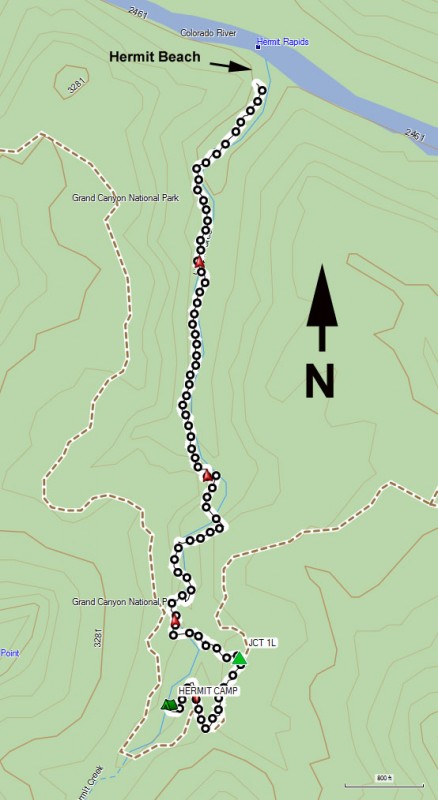
The trail starts its descent down the white sandstone region. The trail drops quickly, almost 2000 ft in the first 2.5 miles. After 1.2 miles of hiking, you reach the signed junction of Waldron trail (JCT_1R on the map), which is an alternate route to the rim of the canyon. Stay on the Hermit trail by keeping right here. After 1.5 miles of hiking, you reach the signed junction of Dripping Springs trailhead (JCT_2R on the map). Again, stay on the Hermit trailhead by keeping right.
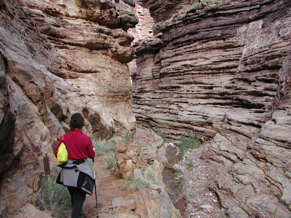
By now you are firmly in the red Hermit Shale region of the Canyon. You will enjoy the increasing view of Hermit Creek canyon as it opens up to the greater Grand Canyon. After 2 miles of hiking, you reach a small rest hut that sits next to Santa Maria Spring. The spring is a small trickle, but it does flow into a tin bathtub size container. Be sure to treat any water you take from this spring. This spring flows for most of the year, but is not considered a perennial spring by the park service.
The rest house is a nice place to take a break, with shade and comfortable places to sit. From this point, the trail levels out as it traverses the Supai section of the canyon. The trail is washed out in several places in this point and requires some boulder hopping to get back on the trail. Even during these sections, the trail is easy to follow, requiring minimal route finding skills. The views of the canyon continue to open as you get closer to Cathedral Stairs. The trail then drops consistently through a series of switchbacks through the redwall section of the canyon, reaching the signed junction between Tonto trail and Hermit trail (JCT_3L on the map). Stay on the Hermit trail for another 0.8 miles to get to the campground. Just before reaching the campground, you will notice the remains of the stables of the tourist camp on your left. Please treat these ruins with respect and don't take or touch anything. Let future generations find this place in the same condition as you do.
The campground has about four campsites with easy access to Hermit creek, a year round source of water. There is also a pit toilet, places to hang packs, and food storage containers. It makes an excellent base to explore Hermit Creek and Hermit rapid. Be sure to treat water from Hermit creek before drinking.
There is a trail down Hermit Creek to Hermit rapid that can be accessed either from Hermit trail (you will notice the sign as you get near the campground - JCT_4L on the map) or by just following down the canyon from the campsite. The trail meets up with the canyon bottom after about 0.25 miles of hiking, so either way is rewarding. There will be some route finding required here, as the trail crosses the creek many times, but as long as you continue down canyon, you will be fine. Keep an eye out for rock cairns to stay on the trail. This is a very lovely canyon, with impressive narrows that gradually open up into a lush desert canyon. Take all day and really enjoy the beauty of this area, it is well worth the extra day in your schedule. After descending 1500 ft and walking 1.5 miles, you will reach the Colorado River and Hermit Rapid. Hermit Rapid is one of the larger rapids in the canyon and if you get lucky, you may get to watch a river rafting party try to navigate the water here.
The return route is the Hermit trail. Enjoy your national park!
