
- Hikes in Arizona
- Tucson Area and Southern Arizona
- Powers Garden
Powers Garden

Location
To get to the trailhead: from the Phoenix area, take HWY-60 East toward Globe. In Globe, take HWY-70 South East towards Safford. From Safford, take HWY 191 South for 17 miles to the HWY-266 junction, Take HWY-266 towards Bonita and Ft. Grant, driving for 19 miles to the Aravaipa Road. Take this well graded dirt road 19 more miles to the well signed junction with FR 253 towards the Deer Creek Trailhead. This dirt road is more rocky and requires a high clearance vehicle. After 8.4 miles of driving on this road, you will see the trailhead parking on your right (not clearly signed, so keep an eye out for it). The trailhead has no water, so bring your own.
Hike details
Season
- March
- April
- September
- October
- June
- July
- August
Solitude
Difficulty
Permits
Hike to Powers Garden near Tuscon, Arizona.
The hike to Powers Garden has a number of highly desired features that make it worthwhile. The solitude in the Galiuro Wilderness is tough to beat. The views along the trail of Mount Graham and Rattlesnake Canyon are impressive. The possibility of viewing wildlife is good, with Black Bears, Mountain Lions, and White Tailed Deer all making this area their home. There are a number of reliable (and pretty) springs in this area. However, perhaps the strongest reason for this hike is to experience the Powers Garden area itself.
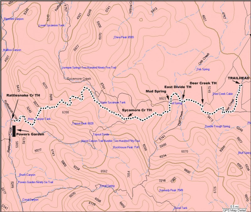
Some things you should keep in mind about this hike before taking off. Route finding skills are a must here. There are a number of places that the trail may fade away and there are several confusing trail signs. Also, the trail shown in the Garmin 1999 Topo map (data version 2.0) shows either the wrong trail location or an old, no longer used trail (I suspect the former). The map below shows the correct location of the trail. It is possible to sleep comfortably in the cabins at Powers Garden, but you may need to share it with any other hikers/equestrian riders that happen to have the same idea. Weather can have a huge impact on the condition of this hike. I have read accounts where Rattlesnake Creek was flowing so heavily that it was not possible to wade across and others where Powers Spring was the only flowing source of water in the area. Finally, since this is a remote area, a fast rescue is not likely here.
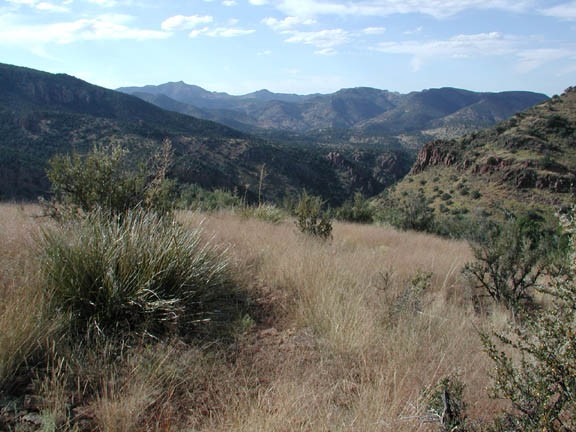
From the parking area, go through the gate (close it behind you) and right away start to develop the route finding skills you will be using for most of this hike! The trail in this area goes through knee to waist high grass so the trail can be very difficult to follow. For the start, cross the small wash and look for the faint trail on the other side. This section of the trail wanders over some grass covered hills. It makes for some unique Arizona hiking, but the trails can be easy to loose. Watching for Cairns can help. After about 1.4 miles of hiking you will reach what is listed as the Deer Creek Trailhead junction. You will take the East Divide trail for a short distance here, climbing up 500 ft in about 1 mile to reach Mud Spring. Mud Spring marks the start of the Tortilla trail.
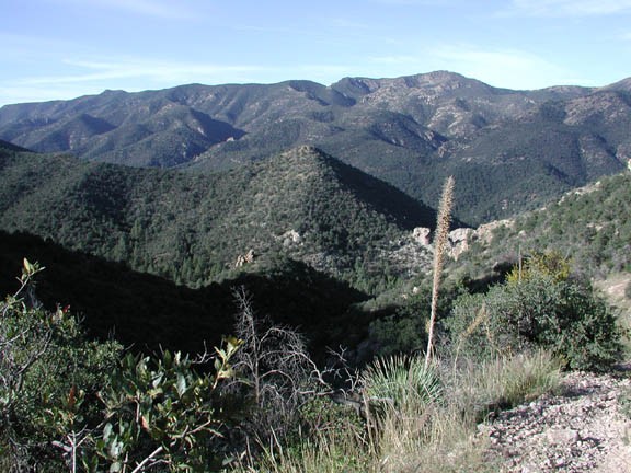
From this point, the climate changes from the grassy hills to more scrub forest. The trail also becomes more rocky as you climb 500 ft to a saddle. This section is about 1.2 miles from Mud Spring. The climb to the saddle rewards you with views to the East of Mount Graham and to the West of the Galiuro Wilderness.
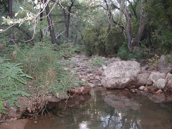
From the saddle, the trail drops a gradual 500 ft over the next mile or so into Sycamore Creek. There is a spring along the creek that is filling what looks to be a cow tank. Soon the trail leaves Sycamore creek to climb over another saddle (about 400 ft of climbing) where it overlooks Horse Canyon.
The trail now drops steeply (900 ft in 1.3 miles) to Horse Canyon and finally to Rattlesnake Canyon. There is a signed junction for the Powers Garden Trail here, which you will turn left on to travel the final short distance to the Powers Garden. As you reach this point, you will notice that you are now in a pine forest, with open meadows and oak trees.
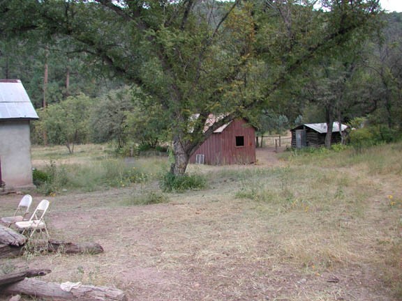
The destination of the hike shows up on your left (West of Rattlesnake creek) as you see a number of fairly well maintained cabins along Rattlesnake creek. It is well worth the time to explore these cabins, which are informally maintained by the hikers and equestrians that periodically visit this area. If you do stay in one of the cabins, please make sure to leave it in better condition than you found it (and sign the log book!). There are black bears in the area, so be sure not to leave any food lying around or the bears will break into the cabin and trash it. Powers Spring is the source of water for the area and can be found a short walk along Rattlesnake Creek. This is quite an idyllic place, with the exception of some mosquitoes, so be sure to set aside some time to explore and enjoy it.
This area was ranched by the Power family starting in 1909. They worked a mine and built several cabins in this area. In 1918, the family was involved in a shoot out with the local sheriff and some deputies that left the Powers patriarch dead as well as three of the four lawmen. The result was a large manhunt for the two surviving Power brothers, eventually resulting in their capture and what would be the longest imprisonment in Arizona state history. The Power side of the story is detailed in the book Shoot-out at Dawn: An Arizona Tragedy, authored in part by Tom Power. The cabin that the shoot-out took place at is still standing, about 5 miles south of Powers Garden along the Powers Garden Trail. In Tom Power's book, he speculates that the reason behind the sheriff's actions against his family was that he wanted control of the mine they had started to work, which is also near the cabin. These would make excellent day hike destinations if you were interested in adding another day to your trip.
There are a number of trails in the area that could make loop hikes of several days, but for this hike, we returned on the same trail.
