
- Hikes in Arizona
- Phoenix Area and Central Arizona
- Limestone Spring Loop(Spur Cross)
Limestone Spring Loop(Spur Cross)
Location
To get to the trailhead: from the Phoenix/Mesa area, take I-17 North to the Carefree Hwy exit. Take the Carefree Highway East about 8.5 miles to Cave Creek Road. Turn left onto Cave Creek Road and drive about 2.7 miles to Spur Cross road. Drive North on Spur Cross road about 4.5 miles, with the last 1.5 miles being graded dirt road. The dirt road is in very good shape and is OK for passenger cars. As of April, 2007, there is a $3 fee to enter the conservation area. There are restrooms at the trailhead, but no water.
Hike details
Season
- January
- February
- March
- April
- October
- November
- December
- July
- August
Solitude
Difficulty
Permits
Hike the Limestone spring trail loop in the Spur cross conservation area near Phoenix, Arizona.
The Spur Cross Ranch Conservation area is one of the newer members of the Maricopa County Park system. The conservation area borders the Tonto National forest to the North and provides an accessible area for hikers to enjoy this still pristine desert. The parking area is a few hundred yards away from the actual trailhead and restrooms.
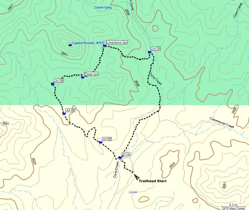
There are several trails in this area. We start on the Tortuga trail, which exits from the West of the starting area.
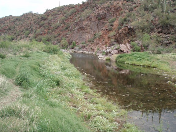
This trail starts out along an old jeep road and quickly crosses Cave Creek, which was running when we did this hike. Some fancy rock hopping will keep your feet dry as you continue generally North-West along this trail.
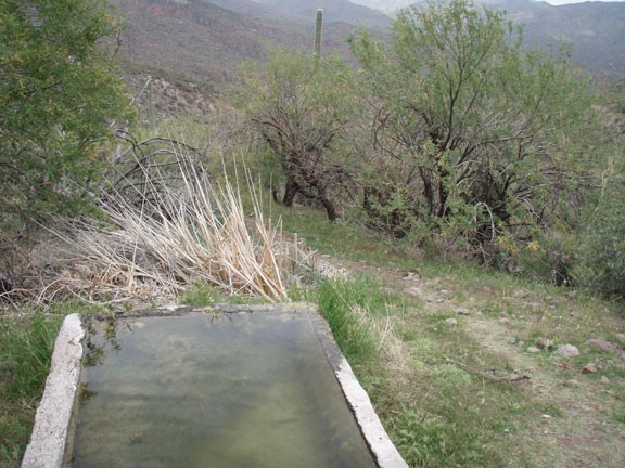
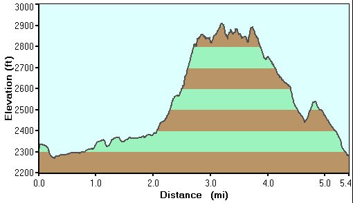
Just after crossing the creek, you reach the first signed trail junction (Marked on the map as JCT 1B). To the left is the Tortuga trail and Elephant Mountain. We will be returning by this route. Now we will turn right, onto the Metate trail. This well worn trail follows along Cave Creek, which may contain seasonal water. When we did this hike, it was just after a rain, so there was water in the creek. After about 1.3 miles of hiking, you will reach a gate and our trail turns into an old forest road. This section of trail is called the Spur Cross trail. Walk on this Northerly trail for about 0.8 miles, keeping your eye out for an old Corral on your left. The junction to the Limestone trail is here, but the junction itself is unsigned (Marked JCT 2B on the map). Head to the back (South) of the Corral, through a gate, to the worn trail. This section of trail is much rougher and rockier than the road, but it is still well worn and easy to follow. The trail heads West here and climbs at a good pace to Limestone spring.
From Limestone spring, the trail heads south west, traversing along the base of Sugarloaf mountain. You will cross a few dry washes here. Keep an eye out for the trail when you enter the wash so you don't take a wrong turn. After crossing a few washes and hiking about 0.5 miles from Limestone spring, you will reach a small fork in the trail. To the left you will see Page spring (about 20 ft down the trail). We will continue to the right. About 0.4 miles from Page spring is the junction to the Elephant Mountain trail. There is a cool Cairn here marking Spur Cross to the left (Marked JCT 3B on map). Follow the arrow left towards Spur cross. From here, it is an easy downhill walk of 1.6 miles along an old jeep road (Tortuga Trail, stay on this trail at signed junctions JCT 4B and 5B on the map) back to the parking area.
