
- Hikes in Arizona
- Sedona
- Telephone Trail 72 and Thomas Point Trail 142 loop
Telephone Trail 72 and Thomas Point Trail 142 loop

Location
From the Phoenix area, take I-17 North to exit 298 to HWY 179 West into Sedona. Follow the signs to 89A North and decide where to park. If you park at the Call o' the Canyon parking area (popular trailhead for Westfork) you'll pay $7. If you pick a point along side HWY-89A between the Westfork parking and mile marker 385, you'll pay $5. If you pick the second option, make sure to get a Red Rock parking pass in Sedona before parking or you risk a ticket. Telephone Trail 72 starts just past mile marker 385.
Hike details
Season
- April
- May
- June
- July
- August
- September
- October
- November
Solitude
Difficulty
Permits
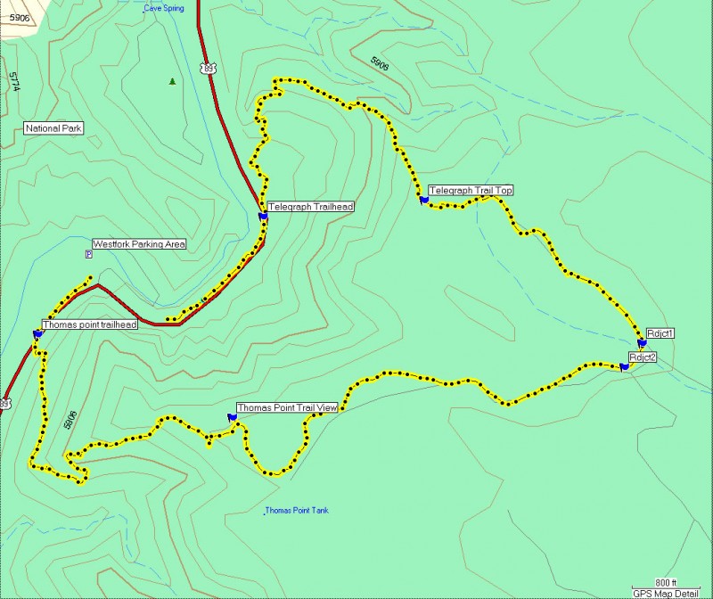
Loop hike with the Telephone trail and the Thomas point trail in Sedona, Arizona.
Warning: Sedona has recently instituted a "Red Rock Pass", which is a fancy way of saying you need to pay to play. As of May, 2007, the fee is $5 per day per vehicle. There are plenty of places in and around Sedona to pay this fee and get the receipt, which you need to put on your vehicle dash to keep from being towed. You will need this if you park along HWY-89A. If you are parking at the Call O' the Canyon parking area (better known as the Westfork trailhead) you do not need a "Red Rock Pass" but you will pay $7 at the entrance to the parking area.
This description is a loop hike that starts from the Call O' the Canyon parking area. You'll finish the hike here, but to get to the Telephone Trailhead, you need to risk life and limb and walk along HWY-89A up canyon for about 0.5 miles. After passing mile marker 385, keep your eye open on the right side for a rust colored metal sign for "Telephone Trail #72".
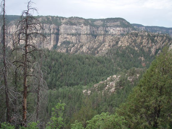
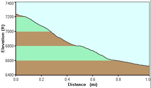
After tracking HWY-89A for a bit, the Telephone trail climbs pretty steeply and steadily. The nice part about this ascent is that it is well shaded by a pine forest. The drawback is that the shade also blocks most of the views until the top. The trail is pretty easy to follow, although there are some spots that can be a bit tricky. If you are confused, look for helpful rock cairns. After about 1.3 miles of hiking, you will reach the rim and after walking a bit away from the rim you will be rewarded with a great view to the North of Oak Creek canyon and the San Francisco peaks.
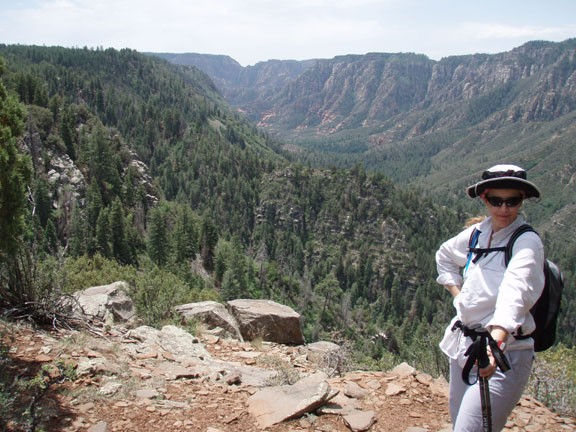
From here, get out your GPS, because it can get a bit tricky to find the top of the Thomas Point Trail. You'll be heading generally East from here. There are a few rock Carins early on to help you find your way, but I would not recommend going any further unless you have a GPS or a map/compass and know how to use it. If you stay going East, you will reach a well defined forest road. Follow this forest road, which will head south east. After about 0.1 miles on this road, there is a spur road heading to the right. I don't know where this road leads, so don't take it. You'll want to take the second road leading to the right after about 0.5 miles. Take this to the right and stay to the right. The road you are following will now start to head West, back towards the rim. Just under a mile from where you turned right, you'll start to see some great views up and down Oak Creek Canyon. A defined trail is observed here heading West to the rim. Follow this trail (being sure to enjoy the great views of lower Oak Creek canyon) to the edge of the rim and a defined trail down. You have now reached the Thomas Point Trail.
From the top of the Thomas Point Trail, the trail is well defined, but steep. This trail starts out with a bit of shade, but this doesn't last long. The nice part is there are great views to enjoy as you descend down the trail, but the drawback is that there is little sun protection. Eventually, you will reach HWY-89A and the rusty metal sign for the Thomas Point Trailhead. Cross HWY-89A (carefully!) and head back to your car.
