
- Hikes in Arizona
- Northern Arizona
- Heart Trail
Heart Trail

Location
From the Flagstaff area, take HWY 89 towards Page, AZ. After you pass the junction for HWY-66 and I-40, and after you pass the Flagstaff mall, the trailhead is about 0.3 miles on the left, past the Townsend-Winona Road. The trailhead is well signed.
Hike details
Season
- June
- July
- August
Solitude
Difficulty
Permits
Hike up the Heart Trail on Mount Elden near Flagstaff, Arizona.
This is an alternative route to the top of the Elden Mountain ridgeline that enjoys greater solitude than the popular Mount Elden lookout trail.
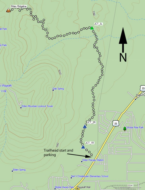
From the trailhead, turn right at the signed junction with the Elden trail (JCT_1R) and stay right again at the trail junction with Fat Man's Pass (JCT_2R). You'll be on the Sandy Seep trail.
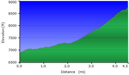
The well signed and easy to follow Sandy Seep trail starts along a relatively flat path through a pine forest. After about 1.5 miles along the Sandy Seep trail is the well signed junction for the Heart trail (JCT_3L). Turn left here. From here, the trail climbs much more steeply through the previously fire burned area on Mount Elden. This section is devoid of trees, leaving a uniquely different approach to the Mount Elden Lookout Trail. There is no shade on this section, so this trail is nice on a cold day. The other benefit to the lack of trees are the unobstructed views of the surrounding area. The Heart Trail eventually switchbacks up to the Sunset trail along the ridgeline. You can turn around here, or you can turn left along the Sunset trail and hike the 1.7 miles to the peak of Mount Elden. Whichever you decide, there are a number of nice places to stop and have lunch while enjoying the views. When ready, return the way you came.
Watch the weather closely. If dark clouds begin to form or you hear thunder or see lightning, call it a day and hustle down the mountain. Lightning strikes the peak of Elden on a regular basis and you don't want to be near it when it does.
